Basic Concepts AssignmentAs you've learned in the reading/lecture and the YouTube videos, all maps have distortions. This is because it is mathematically impossible to accurately portray a curved su
College of Alameda
GEOG 1: Physical Geography Professor Bow
Ch. 1: Introduction to Earth
The goals and objectives of this chapter/lecture are to:
Develop an understanding of how geographers study the world and use science to explain and understand the natural environment.
Develop an understanding of the scientific method and the ways in which it is utilized within the discipline of geography.
Describe the overlapping environmental “spheres” of Earth, and how the concept of Earth systems helps us understand the interrelationships and complexities of Earths physical processes.
What is Geography?
If you're taking this course with the expectation that the study of geography is going to be about memorizing names and places on maps, you'll be disappointed.
Geographers study the location and distribution of things - tangible things such as rainfall, mountains, and trees, as well as less tangible things such as language, migration, and voting patterns. In short, geographers look for and explain patterns in the physical and human landscape1.
Throughout this course you’ll learn about fundamental processes and patterns in the natural world (such as clouds in the sky, streams and valleys, volcanic eruptions, and the plants and animals that thrive in this region). You’ll also learn about human interactions with the natural environment and how events such as hurricanes, earthquakes, and floods affect our lives and the world around us1. We will also examine some of the ways human activities are increasingly altering our environment. By the time you finish this course, my hope is that you’ll have a deeper understanding and appreciation for the Earth and its physical processes.
The word geography comes from the Greek words meaning “Earth description.” Several thousand years ago many scholars were indeed “Earth describers,” and therefore geographers more than anything else. During this time, Chinese, Egyptian, and Phoenician civilizations were beginning to explore the places and spaces within and outside their homelands. The earliest evidence of such explorations comes from the archaeological discovery of a Babylonian clay tablet map that dates back to 2300 BCE2. Click here to see an image of this map as well as other early significant maps.
Over the centuries, there was a trend away from generalized Earth description toward more specialized disciplines – such as geology, meteorology, economics, and biology – and so geography as a field of study was somewhat overshadowed. Over the last few hundred years, geography has reaffirmed its place in the academic world, and today geography is an expanding and flourishing field of study1. Check out The Association of American Geographers website to learn more about what geographers do as well as salary data and trends.
Studying the World Geographically
Geographers study how things differ from place to place, i.e. the distributional and locational relationships of things around the world (what is often referred to as the “spatial” aspect of things)1. Geographers ask two simple questions: where and why? If you are answering those two questions for any location, topic, process, phenomena, etc., then you are using the discipline of geography.
Now, there are HUGE misconceptions of what geography actually is and what it entails.
{Inserting personal anecdote - when I meet someone for the first time and they ask me, “what do you do for a living?” or “what did you go to school for?” and I reply and say “I’m a Geography Instructor” or “I majored in geography”, usually the follow-up question is something along the lines of “what’s the capital of Delaware?” or “what’s the name of that country next to Uzbekistan?”. People assume that geography is locating and knowing names and places on a map. But as mentioned earlier, this is not the case.}
A lot of these misconceptions stem from the fact that geography as a discipline is no longer taught in our K-12 public school system anymore. It *sort of* gets lumped in with history (and usually involves drawing locations on maps), but it’s rarely a separate class with its own separate curriculum. As a result, we tend to associate geography with names on a map – otherwise known as place names. Place names are simple and require no further skill other than basic memorization. Place names (such as the names and locations of the 50 states of the United States or the names and locations of the countries in Latin America or Africa or Southeast Asia) are something we all should have learned in elementary and middle school when our brains were at their peak in terms of memorization. Studies (such as this one) have shown that certain components of our memorization skills begin to decline in early adulthood. There are of course exceptions to this, but my point is that I am NEVER going to ask you to label the state of Arkansas on a blank map. Should you know where Arkansas is? Absolutely. But you don’t need a college professor to teach you that. You can simply print out a blank map and fill it in or you can buy a puzzle of the 50 states or the countries in Eastern Europe or wherever (heck, there’s likely an app for that!). What I’m going to teach you is something that takes a higher skill set and required college-level thinking – spatial analysis, or the where and why of Earth’s physical features.
Since geography is the study of where and why, you can imagine how broad this discipline is. You can study ANYTHING with this discipline as long as you’re answering those two basic questions.
{Inserting personal anecdote - this is one of the things I love most about this discipline. When I first started my undergraduate career (at a community college) I began as a biology major. This wasn’t because I was particularly fond of the subject, it was because I was told, “you need to pick a major.” I chose biology because I was always interested in science and biology was the subject I always did the best in and felt I understood it well. During my first semester I took an English, math, biology, philosophy, and astronomy class. What I realized that first semester is that while I was interested in my biology class I was also really interested in my philosophy class and my astronomy class. The following semester I took English, world religions, history, environmental science, and geography. I experienced the same thing – I was interested in everything. I discovered during the second semester that I could study all of those topics (history, religion, biology, global warming, etc.) within the context or discipline of geography. I switched majors that second semester and have never looked back. 
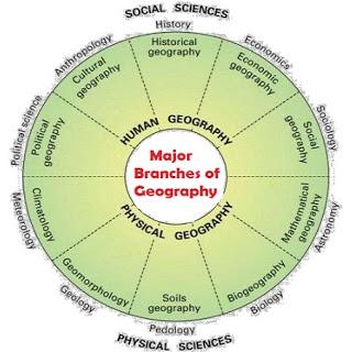
Geography as a discipline is very broad, and as a result, has been divided into two main branches – physical geography and cultural (or human) geography. Physical geography is the spatial analysis (i.e. the where and why) of the physical process and elements that make up the environment. This would include landforms, rocks and minerals, water, weather and climate, plants, animals, soil, etc. Cultural (or human) geography is the spatial analysis (i.e. the where and why) of the human elements and processes that make up cultures, places and societies1. This would include population trends, economic activities, languages, religions, political systems, settlements, food and agriculture, etc. Within these two branches exists many, many other sub-fields (such as historical geography, geomorphology, etc.) as demonstrated by the image below.
Geography, therefore, doesn’t have its own body of facts or objects that only geographers study. The focus of geology is rocks, the attention of economics is economic systems, demography examines human population, and so on. Geography on the other hand is much broader in scope than most other disciplines and therefore qualifies as interdisciplinary (meaning that it relates to more than one branch of knowledge). Geographers, too, are interested in rocks and economic systems and population – specifically, describing and understanding their location and distribution. To provide other examples, a geographer cannot understand the distribution of different soil types without knowing something about the rocks from which the soils were derived, the slopes on which the soils developed, and the climate and vegetation under which they developed. Similarly, it is impossible to comprehend the distribution of agriculture without an understanding of climate, topography, soil, drainage, population, economic conditions, technology, historical development, and many other factors, both physical and cultural. Because of its wide scope, geography bridges the academic gap between the natural (or physical) and social sciences1.
Scientific Inquiry
Science is a path to gaining knowledge about the natural world. The study of science also includes the body of knowledge that has been collected through scientific inquiry. To conduct a scientific investigation, scientists ask testable questions that can be systematically observed and careful evidenced collected. Then they use logical reasoning and some imagination to develop a testable idea, called a hypothesis, along with explanations to explain the idea. Finally, scientists design and conduct experiments based on their hypotheses. Scientists seek to understand the natural world by asking questions and then trying to answer the questions with evidence and logic. A scientific question must be testable and supported by empirical data, it does not rely on faith or opinion. Our understanding of natural Earth processes helps us to understand why earthquakes occur where they do and how to understand the consequences of adding excess greenhouse gases into the atmosphere.
For science to work, scientists must make some assumptions. The rules of nature, whether simple or complex, are the same everywhere in the universe. Natural events, structures, and landforms have natural causes and evidence from the natural world can be used to learn about those causes. The objects and events in nature can be understood through careful, systematic study. Scientific ideas can change if we gather new data or learn more. An idea, even one that is accepted today, may need to be changed slightly or be entirely replaced if new evidence is found that contradicts it. Scientific knowledge can withstand the test of time because accepted ideas in science become more reliable as they survive more tests3. 
Geographic Inquiry
What makes geography different from other disciplines is its focus on spatial inquiry and analysis. Geographers also try to look for connections between things such as patterns, movement and migration, trends, and so forth. In order for geographers to determine the where and why, they use methodologies that are quite similar to the scientific method, but again with a geographic or spatial emphasis. This method can be simplified into a four step process:
Ask a geographic question. This means to ask questions about spatial relationships in the world around you.
Acquire geographic resources. Identify data and information that you need to answer your question.
Explore geographic data. Turn the data into maps, tables, and graphs, and look for patterns and relationships.
Analyze geographic information. Determine what the patterns and relationships mean with respect to your question.
Knowing where something is, how its location influences its characteristics, and how its location influences relationships with other phenomena are the foundation of geographic thinking. This mode of investigation asks you to see the world and all that is in it in spatial terms. Like other research methods, it also asks you to explore, analyze, and act upon the things you find. It also is important to recognize that this is the same method used by professionals around the world working to address social, economic, political, environmental, and a range of scientific issues3.
Environmental Spheres and Earth Systems
One common conclusion of scientific inquiry is that the world of nature is often very complex. To understand this complexity, scientists usually try to envisage the phenomena of nature as simplified versions of reality known as a system. A system can be defined as a collection of interrelated parts that work together by way of some driving process2.
Earth has four systems or spheres:
Lithosphere: comprising the rocks of Earth’s crust as well as the unconsolidated particles of mineral matter that overlie the solid bedrock.
Atmosphere: the gaseous envelope of air that surround Earth.
Hydrosphere: comprises water in all its forms (solid, liquid and gas).
Biosphere: encompasses all the parts of Earth where living organisms can exist; in its broadest and loosest sense.
These “spheres” are not discrete and separated entities but rather are considerably interconnected. This intermingling is readily apparent when considering an ocean - a body that is clearly a major component of the hydrosphere and yet may contain a vast quantity of fish and other organic life that are part of the biosphere3.
Some systems are effectively self-contained and therefore isolated from influences outside that system, and so are called closed systems. It is rare to find a closed system in nature. Earth as a whole is essentially a closed system with regard to matter. Currently there is no significant increase or decrease in the amount of matter (the “stuff”) of Earth, although relatively small but measureable amounts of meteoric debris arrive from space, and tiny amounts of gases are lost to space from the atmosphere. Energy on the other hand, does enter and exit the Earth system constantly3.
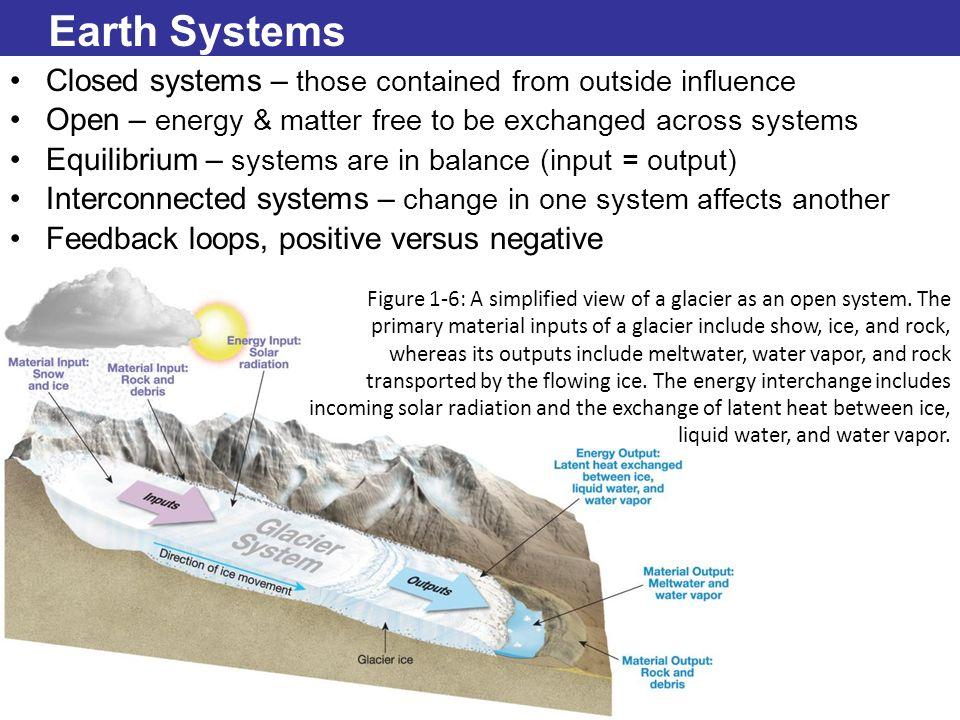
Most Earth systems are open systems, meaning both energy and matter are exchanged across the system boundary. Matter and energy that enter the system are called inputs, and losses from the system to its surroundings are called outputs. For example, a glacier behaves as an open system. The material inputs to a glacier include water in the form of snow and ice, along with rocks and other materials picked up by the moving ice, along with rocks and other materials picked up by the moving ice; the material outputs of a glacier include the meltwater and water vapor lost to the atmosphere, as well as the rock transported and eventually deposited by the ice. The most obvious energy input into a glacial system is solar radiation that melts the ice by warming the surrounding air and by direct absorption into the ice itself3. See slide image on the following page depicting a glacier system.
When inputs and outputs are in balance over time, the conditions within the system remain the same; such a system can be described as being in equilibrium. For instance, a glacier will remain the same size over many years if the inputs of snow and ice are balanced by the loss of an equivalent amount of ice through melting. If, however, the balance between inputs and outputs changes, equilibrium will be disrupted – increasing snowfall for several years, for example, can cause a glacier to grow until a new equilibrium is reached3.
In physical geography, we study the myriad of interconnections between Earth’s systems and subsystems. Continuing with the glacier example, the system of an individual glacier is interconnected with many other Earth systems, including solar radiation, wind and pressure patterns, and the hydrologic cycle. If inputs or outputs in those systems change, a glacier may also change. For instance, if air temperature increases through a change in incoming solar radiation, both the amount of water vapor available to precipitate as snow and the rate of melting of that snow, may change, causing an adjustment in the size of the glacier3.
Some systems produce outputs that “feedback” into that system, reinforcing change. Over the last few decades increasing surface temperatures in the Arctic have reduced the amount of highly reflective, summer sea ice. As the area of sea ice has diminished, the darker, less reflective ocean has absorbed more solar radiation, contributing to the temperature increase – which in turn has reduced the amount of sea ice ever more, further reducing reflectance and increasing absorption. Were arctic temperatures to decrease, an expanding cover of reflective sea ice would reduce absorption of solar radiation and so reinforce a cooling trend. These are examples of positive feedback loops. Conversely, negative feedback loops tend to inhibit a system from changing – in this case increasing a system input tends to decrease further change, keeping the system in equilibrium. For example, an increase in air temperature may increase the amount of water vapor in the air; this greater amount of water vapor may in turn condense and increase the cloud cover – which can reflect incoming solar radiation and so prevent a further temperature increase3.
1 Hess, D. (2014). “Introduction to Earth”. McKnight’s Physical Geography, 3rd California Edition.
2 Pidwirny, M. (2006). "Introduction to Maps". Fundamentals of Physical Geography, 2nd Edition. http://www.physicalgeography.net/fundamentals/2a.html
3 Dastrup, A., Ramjoue, G. (2016). “Into to Physical Geography”. Dynamic Earth: Introduction to Physical Geography. http://www.opengeography.org/physical-geography.html
8


