Write 7 to 10 lines for each question and add reference below. Please do not take Ai assistance. produce me with a plagiarism report Q1 Unit 2. Throughout this unit, we have reviewed different under
Unit 2: At the Beginning: Pre–Contact Peoples, Origins & Culture
How many people were there?In the pre-contact era, before Europeans began sailing across the Atlantic Ocean in search of a route to Asia, Indigenous peoples were distributed unevenly across the Canadian landscape. Most scholars will agree that population density varied according to the ability of the lands to support human life. However, this is where agreement ends, with the size of Canada's Indigenous population continuing to be a disputed and debated issue today. Thoronton (1987) using a procedure called "standard hemispheric depopulation ratio" has estimated the population to be slightly more than 2 million, while Mooney (1928) estimates Canada's population to be close to 200,000 based on tribe-by-tribe estimates from historical materials. Kroeber (1963) takes an environmental carrying capacity approach to reach a similar number, while 500,000 is the number now accepted by Canada's Royal Commission on Aboriginal Health which is derived from averaging low and high estimates. None of these estimates have been determined using methods rigorous enough to be considered credible by the scientific community which is why the debate continues. But, there is no debate on another claim as scholars can all agree: the Indigenous population decreased dramatically after the arrival of the Europeans.
Who were the original inhabitants of Canada?One way to look at the traditional cultures of Indigenous peoples is to consider the culture areas they inhabited before contact with Europeans. A culture area is a geographic region in which different peoples share similar culture traits. Canada's first inhabitants can be divided into two cultural groups, the First Nations Peoples and the Inuit, and within these two groups subdivided further based on small divisions of geographic areas and culture. All Indigenous groups had their own unique cultures long before contact with Europeans and current media often makes the mistake of lumping all Indigenous people together. You will see that there are many different cultural groups within the blanket terms we use to refer to First Nations or Inuit. Remember that culture refers to the ways of life that a people share, language, food, clothes, tools, religion, government, and artistic expression as we are exploring these characteristics in more detail throughout this unit.
Interactive Map Arctic Cultures
Subarctic Cultures
Northwest Coast Cultures
Plateau Cultures
Plains Cultures
Eastern Woodlands Cultures
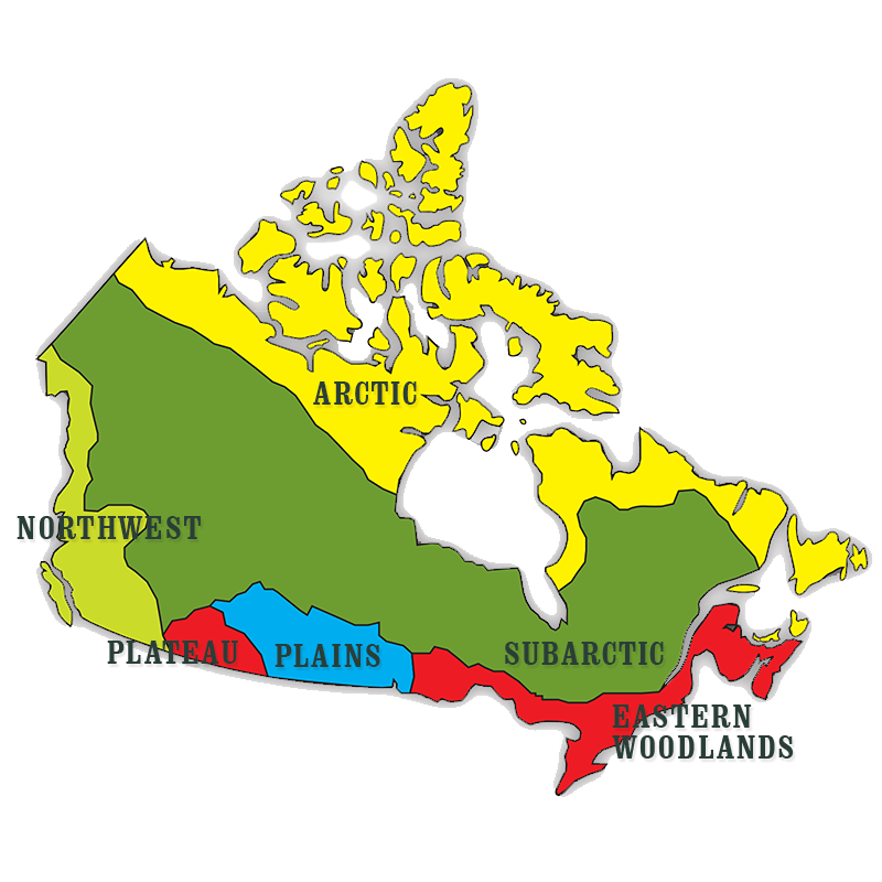
First Nations peoples inhabited five different culture areas throughout the regions known today as Canada. The five major culture areas were: Subarctic, Northwest Coast, Plateau, Plains, and Northeastern Woodlands. Each region offered different natural resources and a variety of climates to the peoples who lived there. Different First Nations within each culture area adopted similar ways of life—similar cultures—because they lived within similar conditions. However the many different First Nations peoples spoke more than 50 different languages and lived diverse life styles shaped by their particular environment.
Although different most First Nations languages within a culture area were part of a language family. A language family is a group of languages that have all developed from one common language in the past, called a proto-language.
Unifying Factors contributing to First Nations Culture: Oral History, Spirituality, and CeremonyAll First Nations told stories orally to preserve the knowledge, experiences, and beliefs of its people. These stories are still told today. They make up each nation's oral history. Storytellers told stories about actual events in the history of a nation and to teach lessons about everyday life.
Oral histories also enabled First Nations to pass down religious and spiritual knowledge through the generations for hundreds, if not thousands, of years. Shamans were the guardians of this religious knowledge—the mythologies and ceremonies. Religious and spiritual ceremonies were rich and diverse among First Nations. Shamans would often preside over these ceremonies, examples of which were the sundance of Plains nations, winter ceremonies of Northwest Coast nations, and shaking tent ceremonies of Subarctic nations.
One example of an individual's spirituality was the vision quest. A young person, before or at puberty, would go alone to a wilderness area to fast and meditate. The purpose was for the young person to receive a vision or a dream. They sought to gain a guardian spirit power to support and protect them through life.
Though the religious beliefs and ceremonies among First Nations were varied, some ideas were shared among most First Nations—ideas that are still held today. One example is The Great Spirit or Creator who created Earth and all things on it. Storytellers passed down many different creation stories. For example, many creation stories describe the Great Spirit diving into the primeval water to dig up mud, from which he made the Earth. Other creation stories might involve a changeling or transformer (Nanabooshoo in Anishinaabe or Wesakechak in Nehiyaw) who takes light, fire, water, food, animals, and people. The Trickster sets all these elements loose, which creates the world as it is now.
All living and non-living things that the Creator made are interrelated in a great circle of life. Because each thing on Earth has a spirit, it should be respected and cared for. For example, when taking the life of a plant or animal, a First Nations person pays respect to its spirit. First Nations hunters have great respect for and gratitude to the animals they kill for human survival. Hunters offer or burn tobacco to acknowledge this gift of animal life.
InuitInuit and their ancestors are the Indigenous peoples who lived in the Arctic for thousands of years before Europeans arrived. The Arctic is a vast region that is north of the Arctic Circle. The Inuit developed ways of life that were highly adapted to the harsh Arctic environment. Like First Nations people the borders of what is now Canada did not apply to Inuit cultural groups. The Inuit can be sub-divided into eight distinct cultural groups: Labrador, Ungava, Baffin Island, Iglulik, Caribou, Netsilik, Mackenzie and Copper Inuit peoples, based on geographic location.
Although all Inuit people at this time spoke the same language—Inuktitut—each group spoke a different dialect. Most of these Inuit groups still exist today, and many Inuit still live in the traditional Arctic areas in which their ancestors lived.
Unifying Factors contributing to Inuit Culture: Cooperation, Resourcefulness, and Oral historyAlthough there are variations in landforms and climate throughout the Arctic, there are aspects of the environment that are similar throughout the Arctic region. For example, Arctic winters are long and extremely cold with few hours of daylight. Summers are relatively short, but with many hours of daylight and moderate temperatures. No trees grow in the Arctic, but there are low, shrubby plants, many of which produce edible berries. These factors affected evolution of culture for all Inuit groups who lived throughout the Arctic region.
The Inuit lived in small bands comprised of two to five families. Close cooperation and sharing among families was a critical feature of Inuit life because it was important for survival in such a harsh climate. Hunting was often a collaborative activity, where many men would work together to catch larger game and the catch would be distributed evenly throughout the band. If one family were in difficulty, either more resources would be given to them or children would be re-distributed to other band members until difficulties were overcome. If an elder felt they could no longer contribute to the band, he or she would wander away from the group to die on the land, rather than consume the hard won resources of the group.
Because of the scarcity of resources, nothing was allowed to waste and everything available in the environment was used. One of the most iconic examples of this is the igloo. The snow-house style of igloo—today considered a major technological success—was made from blocks of packed snow (not ice) and built into a dome. It might hold up to 20 people. Long tunnel entrances provided storage space; the entrance tunnel opened into the house below floor level. Inside, there would be cooking pots, oil lamps, and low platforms for sleeping and sitting. Some Inuit lined the walls with caribou skins for insulation. Some snow houses even had a window set in the roof made of clear lake ice. Some groups would live in snow houses through the winter, while others, such as the Labrador Inuit, might live in a different style of igloo—houses built partly underground that were made of driftwood, sod, stone, and whalebone depending on what was available. In summer, or when there was too little snow or ice to build a snow house, Inuit lived in tents made of animal skins. The tents were weighted down around the edges by rocks.
The Inuit depended on hunting and fishing, hunger and even starvation were common when fish and game were not plentiful. Meat and fish caught in summer were stored in shallow pits that were dug down to permafrost and covered with piles of stones to keep out hungry animals. Because there was little wood in the Arctic to make fires meat and fish were often eaten raw. The skins of seal or caribou was used for everything from the construction of boats (umiaks and kayaks) to shoes (mukluks or kamiks), trousers and parkas. Different skins were used for different seasonal clothing based on insulating and water resistant characteristics needed.
An individuals story might have been recorded on the decorations of a parka, and carving —an ancient art that is still practiced today also served to record and share stories. Inuit carved tools, weapons, and objects of art. Bone, ivory, wood, and soapstone (a soft stone) were used to make small figures of people and animals. Tools were carefully carved to fit the hand of the user. In western areas of the Arctic, masks were carved of wood, painted, and decorated with feathers and animal skins.
Inuit had a close spiritual relationship with the natural world around them which was passed down though oral tradition. There were no gods, but the cosmos were filled with souls of humans, animals, spirits, and inanimate objects. Inuit also believed in other worlds beneath the sea, inside the Earth, and in the sky. Angakoks, or shamans, were thought to be able to travel in trances and dreams to these other worlds and communicate with souls. Stories told of shamans visiting these worlds, transforming into animals, and visiting Sedna—the half woman half fish goddess of all sea creatures. In each new hunting season, pieces of liver of the first-killed sea mammal were returned to the water to please Sedna to give up her sea creatures to the hunters so that the people would have food.
Unit 2: Interactive Map Arctic CulturesThe Inuit live in the unique and extreme environment known as the Arctic, spanning from the Alaska boarder to the eastern Atlantic shores within Canada. It is a vast territory, spreading more than 6,000 kilometres through six time zones. Temperatures in the Arctic vary across the enormous expanse of land. Daily temperatures in the coldest months range from minus 30-40 degrees Celsius in the central and eastern ranges of the arctic to a high of minus 10-20 in the western parts of the Arctic. Average temperatures in the warmest months range from 2-15 degrees throughout the region. Despite some warming in the summer, arctic ground remains frozen throughout the year because of long, intensely cold winters. Annual rates of snowfall are relatively light considering the regions northern location resembling desert areas in terms of moisture received. Ice can cover much of the ocean areas and lakes throughout much of the year. Arctic vegetation is composed of small plants, which all grow relatively close to the ground forming, what is known as tundra.
Living in the arctic environment has led to the Inuit possessing a number of physiological and biochemical adaptations. Their bodies have adapted to extreme cold by mechanisms that protect against heat loss and by the ability to digest high amounts of animal protein and fat in their diet which helps to preserve body heat. Inuit metabolism produces a greater amount of body heat than most people by a measure known as "basal metabolic rate" which indicates that the Inuit have a 33% higher rate than the rest of the population. These and other adaptations have enabled the Inuit to survive and live in the forbidding environment of the arctic.
Subarctic CulturesThe Subarctic culture area was a cold, wet region of forests, mountain ranges, and tundra. It extended from what is now known as Newfoundland and Labrador in the east to the Yukon Territory in the west. It was a harsh climate for human survival in which temperatures could dip to –40°C in winter; while, in summer, temperatures could rise to 30°C. There were immense numbers of rivers, lakes, swamps, and muskeg (waterlogged land), making travel possible only by canoe in summer and toboggan and snowshoes in winter.
First Nations in the subarctic culture area included the Nehiyaw (Cree), Beothuk, Innu (Montagnais-Naskapi), and Thcho (Dogrib) among others. All First Nations of the Subarctic can be divided into two major language families. The first—the Athapascan speakers—lived in the western regions of the Subarctic. The second—the Algonquian speakers—lived in the eastern regions of the Subarctic.
Subarctic peoples ate a protein-based diet of game (caribou, moose, hare) and fish (salmon, pike, whitefish, trout) that were hunted and trapped with bows, arrows, and snares, or caught with nets, spears, hooks and lines. If food was scarce, one nation might grant hunting rights to another to share the resources of a particular area. When food was plentiful in summer, two or more nations might live together. Wild plants were gathered, but there was no farming in the extreme climatic conditions of these regions.
First Nations of the Subarctic lived in small groups of 25-30 people who frequently traveled to different locations—often long distances— depending on the availability of game and other resources.
There were no formal chiefs in subarctic nations, though individuals would take on leadership roles. Adult men and women contributed to decision-making within a group. Families or individuals who did not agree with group decisions were free to leave or find a new group to live with.
Northwest Coast CulturesThe Northwest Coast was a coastal area stretching from today's Vancouver Island in the south up past the Queen Charlotte Islands in the north. The climate here was more hospitable than other culture areas. Temperatures rarely fell below freezing in winter and were moderate in summer. Some of the First Nations of the Northwest Coast included the Tlingit, Haida, Tsimshian, Kwakwaka’wakw (Kwakiutl), Nuu-chah-nulth (Nootka), and Coast Salish. The languages of the Tlingit and Haida peoples were unique among the Northwest Coast First Nations, as they had no relationship to other First Nations languages. The languages of other nations in this region are related to the Penutian, Wakashan, or Salishan language families.
First Nations of the Northwest Coast inhabited an area with abundant resources that were drawn from land and water. Salmon-spawning streams brought several species of salmon to this area, providing great quantities of salmon to eat each year. Fish and shellfish were also harvested from the Pacific Ocean: candlefish, herring, halibut, among others; sea lions and whales; mussels, clams, and oysters. Roots and berries were also gathered. Animals, too, such as caribou, moose, and mountain sheep were hunted for food. Tools, clothes, and shelters were made from animal bone and skin.
The population of Northwest Coast villages were about 100 or more. One feature common to all nations in this region was that each village had a hierarchical system of ranking its people. The social status of each person in the village was ranked according to how closely related they were to the headperson or chief. War captives and people in debt were not included in this ranking system, as they were thought of as outcasts.
Potlatch ceremonies helped to establish or maintain the social status of a family by demonstrating the host’s generosity. A potlatch could mark family events, such as births and marriages, or help to build political alliances among different First Nations. Different First Nations held potlatch ceremonies for different reasons and in different ways, but many traditions were common in all communities. A chief would invite guests to the ceremony to share gifts and food, along with singing, dancing, and speeches. Stories were retold to preserve the oral histories and knowledge of the people.
An individual or group’s wealth was assessed based on valuable possessions such as cedar-bark blankets, dentalium shells, dried fish and fish oil, dugout canoes, and coppers. Coppers were pieces of copper that were hammered into a shield, often decorated with designs or crests. Coppers increased in value when they were traded between families at potlatch ceremonies.
Plains CulturesPlains First Nations—Siksika (Blackfoot), Nakota (Assiniboine), Plains Cree, among many others—inhabited areas with flat land and rolling hills. This region covered territory east of the Rocky Mountains into what is today known as southern Manitoba. The climate brought hot, dry summers and very cold winters. The water supply was limited and came only from rivers that moved east through this region. Trees were found only in river valleys.
Millions of bison—buffalo—migrated through the Plains each season and fed upon the grasslands of these areas. Though Plains peoples relied upon other resources for their survival, bison was an enormous natural resource around which Plains First Nations’ cultures developed.
When hunting bison, men would use animal skins as a disguise to get up close to an animal to kill it with bows and arrows. Another method of hunting would involve guiding a herd of bison over the edge of a cliff. Women cooked some of the bison meat for immediate consumption; the remaining meat was dried for the winter, or mixed with berries and fat to make pemmican. Other parts of bison were used to make tools and clothes. Bison dung was used for fuel, as there were no trees on the plain to use as firewood.
Small, independent groups of Plains peoples were advised, not ruled, by chiefs. A chief’s decision required the approval of the council of elders. These groups followed and hunted the bison herds, which was a nomadic way of life. Plains peoples transported their belongings with the help of dogs who pulled a travois—two long poles with a framework to hold the goods. The travois frame had another purpose: The frame was covered by bison skins to make a conical-shaped dwelling called a tipi.
Through winter months, Plains peoples settled in camps. Only in midsummer when bison formed in larger herds did many groups come together for ceremonies and celebration.
The languages spoken by Plains First Nations belonged to three language families—Algonquian, Siouan, or Athapaskan. Although languages within each language family had the same origins, many of the languages were very different. This could make communication among different nations difficult, leading to the development of hand gestures or sign language.
Eastern Woodlands CulturesAs its name suggests, the Eastern Woodlands were filled with vast forests—deciduous in some regions and mixed coniferous-deciduous in others. This culture area covered territory from what are today known as Ontario’s Great Lakes, through southern Québec, and into the Maritime Provinces. Nations who lived in these regions included the Tionontati (Petun), Ouendat (Huron), Saulteaux (Ojibwa), Algonquin, Mi’kmaw (Micmac), and many others. The many First Nations of these regions fell into one of two language families: Iroquoian and Algonquian.
Hunting, fishing, and farming were the means of survival for Eastern Woodlands nations. First Nations who lived in warmer southern regions relied heavily on growing beans, corn, and squash for food, as well as white-tail deer for animal protein. Nations further north where it was colder relied on caribou and moose. Inland waters provided fish to some nations, while nations who lived near ocean coasts would hunt for seals. Bows, arrows, traps, and snares were used to hunt animals; nets, hooks, and weirs to catch fish. When available, nuts, berries, tubers, and wild rice were gathered.
Nations that relied heavily on farming were able to store crops. This enabled these nations to establish more permanent villages. The populations of these villages might vary between a few families to more than two thousand people. Many related families would all reside in a single longhouse, based on a matrilineal arrangement. A man, upon marrying, would move into his wife’s family’s longhouse. Inheritance would follow the female line.
For other nations, hunting was the most important means of survival, which led to the use of less permanent dwellings than those used by agriculturalists. These less-permanent dwellings—tepees and wigwams—were smaller than longhouses. Village populations among these nations would vary with the seasons.
Most Eastern Woodland peoples had a village chief. Some peoples may have had both civil chiefs—those who dealt with day-to-day village concerns—and war chiefs. Nations in this culture area also developed a larger democratic governing body called the Six Nations Confederacy, or Haudenosaunee. The Confederacy, formed between 1400 and 1600, was at first a political alliance of five First Nations: Kanien’kehá:ka (Mohawk), Oneniot’á:ka (Oneida), Ononta’kehá:ka (Onondaga), Kaion’kehá:ka (Cayuga), Shotinontowane’á:ka (Seneca). Later, they were joined by a sixth nation: the Tehatiskaró:ros (Tuscarora). All chiefs within the Confederacy were equal in rank and authority. This democratic form of government represented the peoples of each nation and included equal participation of women and men. The government process was passed down orally through the generations. The unwritten constitution of the Confederacy is called the Kaianeraserakowa (the Great Law of Peace).
Unit 3: Perspectives on First Contact The First ExplorersSoon after Christopher Columbus landed in the "New World" in 1492, other European nations began sending expeditions to explore the lands across the sea. In the beginning they were looking for a route to the silk and spices of Asia. Soon they realized these new lands held their own riches.
European monarchs and aristocracy believed in the concept of imperialism. They thought they had the right to dominate, claim, and colonize any lands they found. They hoped for riches like the gold and silver Spain laid claim to in South America. However, even monopolizing trade with any distant land had the potential to increase their wealth, power, and prestige.
Leif EricsonAbout the year 1000 the Viking Leif Ericson sailed from Greenland (the island discovered by his father Erik the Red) and explored the east coast of what is now Canada naming the area of Newfoundland and Labrador 'Markland'. Archaeologists excavating at L'Anse aux Meadows, Newfoundland found the remains of buildings and Norse artifacts proving there was a settlement, though no one knows who or for how long. Another 500 years passed before there were any permanent European settlements on the continent.
John CabotAn Italian Giovanni Caboto (John Cabot) wanted to look for a route to Asia, north of the route taken by Columbus. He won the backing of English merchants and King Henry VII. In May of 1497, Cabot left Bristol England with a crew of 18 including his three sons. On June 24, they reached land and claimed it for England. It was probably Newfoundland or Cape Breton in what is now Canada. This is the first known landing of Europeans in North America since the Viking Lief Erikson 500 years earlier.
After exploring the coast for about a month, Cabot returned to England to much acclaim. He reported that they had reached Asia. He and his men also reported an abundance of fish in the waters of the new land. The king was impressed enough to fund a second trip the next year with five ships and 300 men, but Cabot never returned. It is not known what happened to Cabot or the ships. Cabot's first voyage became the basis of the English claim to North America and the reports of fish triggered the annual spring voyage across the ocean of European fishing ships and whalers.
Others followed such as Portuguese explorer Gaspar Cortes-Real who claimed Newfoundland and Labrador for Portugal in 1500. João Alvares Fagundus, who was also Portuguese, explored the same coast in 1521. Italian Giovanni du Verrazanno claimed land further south for France in 1524 and called it Arcadia. These explorers were all looking for a route to Asia. Most expeditions were funded in part by merchants looking for trade opportunities.
Jacques CartierLike many explorers who sailed to America, the French explorer Jacques Cartier hoped to find a route through the continent to Asia. He did not find a route, but during the three expeditions he led, Cartier was the first recorded European to explore the St. Lawrence River. He was also one of the first Europeans to attempt a settlement in what is now Canada.
Cartier's First Voyage - 1534In 1534, King Francis I of France sent Cartier to search for a northwest passage. Cartier sailed into what became known as the Gulf of St. Lawrence through the Strait of Belle Isle. He and his men explored the coasts of what are now Newfoundland, Prince Edward Island, and New Brunswick naming points as they travelled. In Chaleur Bay, they were approached by Mi'kmaq who indicated that they wanted to trade their furs. It is likely that they were accustomed to trading with the crew of European fishing ships. Outnumbered by the Mi'kmaq, Cartier was at first reluctant to deal with them and fired cannon shots over their heads. However the next day, he and his men went ashore to trade knives and tools for their furs.
While on what became known as the Gaspé Peninsula, Cartier had a friendly encounter with a fishing party of Haudenosaunee (Iroquois). They were from the village of Stadacona located near the present day city of Quebec. Before leaving to return to France, Cartier erected a cross and claimed the land for King Francis I. This did not sit well with the Stadacona. Chief Donnacona and his sons paddled a canoe out to Cartier's ship to let them know that he did not approve. Cartier indicated through sign language that the cross was a marker to help him find his way back to that location. Possibly this satisfied the Donnacona, because Cartier took the chief's two sons Domagaya and Taignoagny with him to France.
Cartier's Second Voyage – 1535Cartier did return in 1535 with Domagaya and Taignoagny to navigate the ship up a great river to "kanata" their word for village. Cartier and his crew were likely the first Europeans to sail up what he called the rivière de Canada (St. Lawrence). Donnacona was happy to have his sons back and welcomed them with a feast. However, he discouraged any exploration further up the river that Cartier and King Francis hoped would lead to the Pacific or gold.
Regardless, Cartier carried on up the river as far as the Haudenosaunee village of Hochelaga where they were welcomed, but communication was difficult. Cartier got the impression that gold, silver, and copper could be found by following another river leading north from the St. Lawrence. Since the St. Lawrence was blocked by rapids, Cartier climbed a steep hill to have a look at the other river. He named the hill Mont Réal (Mount Royal) and today the city of Montreal stands on this site.
Cartier returned to Stadacona in October, where his men were building a small fort. It was a cold winter and with no fresh fruits or vegetables, most of the men got sick from scurvy. Though relations with the Stadacona were strained, Cartier finally learned from them how to brew a tea from white cedar as a cure, but it was too late for the 25 men who died. When Cartier returned to France the next spring, he had to leave one ship behind, however he took 10 of the Stadacona with him, including Donnacona. All but one of the 10 Haudenosaunee died in England before his next voyage.
Cartier's Last Voyage - 1541Cartier had failed to find a north-west passage to Asia, but the Haudenosaunee reports of gold and silver caught the king's attention. To ensure France's claim to the land and any possible riches, Cartier was sent back in 1541 to establish a settlement on the river. An expedition of 10 ships was planned to be led by Jean-François de la Rocque de Roberval, with Cartier as navigator. Roberval's ship was not ready, but Cartier set sail on schedule.
The Stadacona did not welcome the French this time, so Cartier built a fort downriver at a place he named Charlesbourg-Royal. Once again the winter was cold and there was hostility with the Stadacona who no longer trusted the French. At least 35 of the men died or were killed. Despite orders to establish a settlement, Cartier and the surviving men returned to France in the spring with what they thought were gold and diamonds. The "gold" and "diamonds" proved to be worthless iron pyrite and quartz. Cartier never returned to North America, but his exploration helped to establish European knowledge of the geography of the land and he gave many place names to European mapmakers including the name Canada.
Samuel de ChamplainSamuel de Champlain was a French explorer, colonist, and mapmaker. His sketches and books provide a vivid picture of his travels in the land that became Canada and the lives of the First Nations. Often called the "Father of New France", Champlain founded the city of Quebec in 1608. He was largely responsible for its success as a colony and France's claim in North America.
Port RoyalChamplain first visited Canada in 1603 as a passenger on a trading ship that stopped in Tadoussac and then went on to the site of the present day city of Montreal. The following year he accompanied Pierre Du Gua de Monts and about 80 settlers to Acadia to establish a colony. De Monts had been granted a trade monopoly in New France. They explored what became known as the Bay of Fundy for a temporary site and chose the island of St. Croix. It was a disastrous winter. Many of the settlers died from scurvy and they burned all the trees on the island for heat. In the spring, the settlement moved across the bay to a place they named Port Royal (Annapolis Royal).
More settlers came from France in 1605 and the Port Royal colony survived. They grew some food, but relied on the ships that came each spring for supplies. Champlain spent much of his time in Acadia exploring and mapping the Atlantic coast from Port Royal to Cape Cod. In an attempt to bolster spirits during the winter of 1606, he began a club named the Order of Good Cheer. The men were encouraged to outdo each other in planning elaborate meals and festivities. However, when de Monts' trade monopoly was cancelled in 1607, most of the settlers returned to France.
QuebecIn 1608, de Monts sent Champlain to establish a fur trading post and colony inland on the St. Lawrence River. Champlain chose the site of the abandoned Haudenosaunee (Iroquois) village of Stadacona which provided access to the interior via the river and a good vantage point for controlling trade. No one knows what happened to the Haudenosaunee. Possibly warfare or European diseases brought by Cartier wiped out the villages north of the river. Champlain called this settlement Quebec from the Algonkian word "kebec" meaning where the river narrows. The workmen Champlain had brought with him, spent the summer building the "Habitation of Quebec". Champlain spent the rest of his life trying to get financial support for the future capital of New France and this first permanent French settlement in New France.
Champlain quickly developed trade relationships with the Innu (Montagnais) who had been travelling to Tadoussac to trade with the French. To build and maintain these trading relationships over the years, he joined the Innu and their First Nations allies in raids on their enemies the Haudenosaunee (Iroquois). For many years, there had been ongoing warfare between two alliances of First Nations; the League of Five Nations Haudenosaunee Confederacy with their allies living south of the St. Lawrence and the Ouendat (Huron) Confederacy with their allies including the Innu and the Kichesiprini (Algonquin) living north of the St. Lawrence.
In 1609, Champlain accompanied a war party of Innu, Kichesiprini, and Ouendat up what is now the Richelieu River to a lake that was named Lake Champlain. There Champlain helped his allies defeat the Iroquois who had never before seen European guns. This success cemented the French alliances. However, it made enemies of the Haudenosaunee who soon developed alliances and trading relationships with the Dutch who settled on the Hudson and ultimately the British in New England.
Champlain spent the winter of 1609–1610 in France working with de Monts to secure financial support for Quebec from French merchants. On his return he joined another war party against the Haudenosaunee who were once again defeated on the Richelieu River. Also that year, he sent Étienne Brûlée to live with the Ouendat to learn their language and customs. This strategy was designed to build bonds between the Ouendat and the French and other young men followed. Champlain's personal relationship with the Ouendat grew stronger over the next few years as he travelled with them exploring most of the Great Lakes area and raiding the Haudenosaunee.
Henri de Bourbon, Prince de Condé assumed responsibility for New France in 1612. He confirmed Champlain as his lieutenant in New France which increased Champlain's powers to those of a governor. Though he was not given the title of governor, Champlain was no longer just the agent of a fur trading company. The king reminded him of the importance of the search for valuable minerals and a route through the continent. In 1613, Champlain travelled north up the river Cartier had seen from Mont Réal, which became known as the Ottawa River. His mission was to try to convince the Kichesiprini to come to the rapids to trade with the French. On this trip, he lost his astrolabe while portaging. It was discovered in 1867 and is in the Canadian Museum of Civilization. Also in 1613, Champlain's book Voyages and detailed map of New France were published.
Two years later, Champlain accompanied a party of Ouendat up the Ottawa River to Lake Nipissing, and their territory on what became known as Lake Huron. He had travelled the route that was to become the main highway of the fur trade as the population of fur bearing animals declined in the St. Lawrence region from too much trapping.
While visiting with the Ouendat, he joined a war party in an attack on the Oneida and Onondaga of the Haudenosaunee League in their lands at the eastern end of Lake Ontario. They travelled down what are now Lake Simcoe and the Trent River. An attack on a fortified Haudenosaunee village was futile. Champlain was wounded in the leg and spent the winter with the Ouendat while he healed. During this time he learned much from them about their culture and the geography of the land.
Champlain's exploring days were over, but he had acquired a working knowledge of the main First Nations' trade routes from Acadia to the Great Lakes. He devoted himself to developing the colony and his efforts included bringing four Recollet priests to try to convert the First Nations peoples to Christianity. In 1618, he submitted a plan to King Louis XIII for developing farming, mining, and forestry and requested families, soldiers, and priests be sent from France. Champlain believed that it was essential to develop colonies to protect French interests from the Dutch and English. His constant efforts to get support for the struggling colony were rewarded in 1627. Cardinal Richelieu organized the Company of 100 Associates to promote colonization as well as the fur trade.
However, in 1628, Quebec was threatened by David Kirke, an English privateer who intercepted ships with settlers and supplies sent to Quebec by the company. The following year Champlain was forced to surrender his starved-out post to the English privateers. However, thanks in part to Champlain's efforts, Quebec was restored to France by the Treaty of St.-Germain-en-Laye in 1632. Champlain devoted his few remaining years to rebuilding Quebec, which had fallen into ruins under the English fur traders.
When Champlain died in Quebec in 1635, only 150 settlers lived there. Champlain's fur-trade network, however, had laid solid foundations for the French empire in North America.


