Print out the lab and complete by hand. Then please scan the document and post here.
• Geog 301 Page 5 of 4

KEY
Wind, Pressure, The Station Model

Part 1: Wind
The following maps show hypothetical pressure areas in North America. Pressure is given in millibars. The top map shows surface pressure. The bottom map shows pressure in the atmosphere (8000 ft).
Draw arrows to show the direction of wind on each of these maps. Each map should have around 9 arrows. Be sure to consider the differences between higher atmosphere (geostrophic) and surface level winds as explained in this week’s reading. *Note: this is a model. You do not need to be exact. One arrow has been drawn on each map to get you started. Your map should use around 7 arrows.
Draw a star or circle an area with steep pressure gradient on each map.

Surface Pressure

 SAC = 1.50 x 4min/ = 6.00min = 6min 0 sec


Upper Atmosphere Pressure
Compare Map A to Map B on the previous page. Which map will have faster winds? Why?
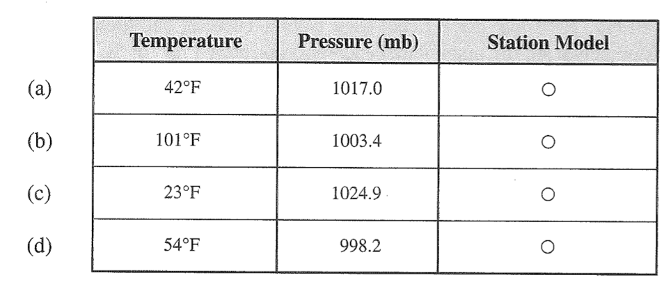
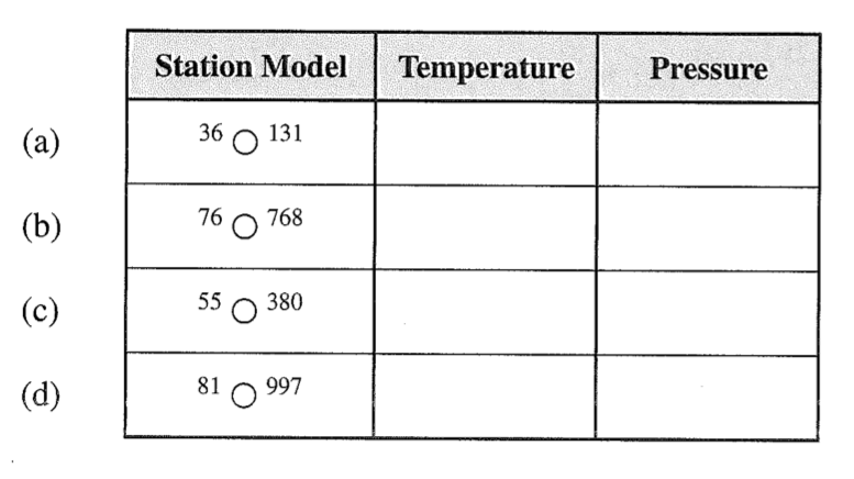
Part 2: Station Model
The graph below provides data for temperature and pressure. Use the station model to represent this data. Follow the guidelines from this week’s reading.
The graph below gives temperature and pressure information using the station model for weather maps. Convert these station models to give their temperature and pressure readings.
Part 3: Drawing Isobars and wind patterns
Below is a simplified weather map of North America showing sea level pressure readings at weather stations in millibars. *Note these readings have been written out in their entirety, they are not abbreviated. Use this map to draw isobars and label an area of high pressure, and an area of low pressure. This activity is similar to the previous isoline activity we completed in class.
Label the map with isolines, drawing an isoline every 4 millibars. One line has been drawn for you to get you started.
Once you have drawn your isobars, label the center of high pressure with “H”
Label the center of low pressure with “L”
Just as you did in Part 1 of this lab, draw lines representing wind direction on this map. Remember this is a sea level map.


Part 4: Reading a Weather Map
This link takes you to a high-definition Weather Station Map from February 27, 2022. This map uses the abbreviated station model.
https://www.wpc.ncep.noaa.gov/sfc/sfcobs/sfcgif21Z_large.gif
Answer the following questions using this map. You can zoom in to see details of regions on the map.
Find the observation for Sacramento International Airport (Abbreviated SMF)
What is the wind direction?
What is the wind speed?
What is the pressure reading?
Find the observation for La Grande/Union County Airport in Northeastern Oregon (Abbreviated LGD)
What is the wind direction?
What is the wind speed?
What is the pressure reading?
Find Texas on the map. Do you notice a pattern in wind direction? Propose a theory for the prevailing wind pattern in this area.


